Gov.co
  • ES
  • English
  • FR
Comando General de las Fuerzas Militares de Colombia
Comando General Fuerzas Militares de Colombia

Navegación principal

  • Home
  • Transparency and Access to public information
  • Services
    • Requests, complaints, claims, suggestions, and reports (PQRSD)
    • FAQ
    • Procedures
  • Participate
    • General Description
    • Diagnosis and identification of problems
    • Planeación y presupuesto participativo
    • Consulta ciudadana
    • Colaboración e innovación
    • Rendición de cuentas
    • Control social
  • About Us
    • About Us
    • Cultura militar
    • Dependencias
    • History
    • Chain of Command
    • Organization Chart
  • Join
    • Libreta militar
    • National Army
    • Colombian Navy
    • Fuerza Aérea Colombiana
  • News
    • Noticias
    • Periódico Las Fuerzas
    • Insignia

Conocenos

  • Quiénes somos
  • Historia
  • Organigrama
  • Cultura militar
  • Línea de mando
  • Dependencias del Comando General de las Fuerzas Militares
  • Memoria histórica y contexto

Ground-penetrating radars will strengthen humanitarian demining operations

Radares de penetración terrestre fortalecerán operaciones de desminado humanitario

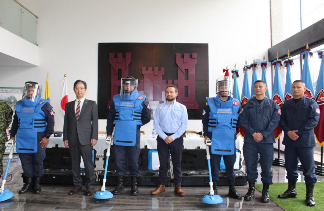
In a protocol ceremony, the government of Japan provided a new tool to strengthen Colombian National Army's humanitarian demining operations in Colombian territory.


There are three ground-penetrating radars that will be used in departments such as Caldas, Santander, Tolima, Caquetá, Meta, Huila and Putumayo.


This advanced landmine imaging system (ALIS) consists of an image sensor that leads to a metal detector or a radar to use it effectively and accurately.


In this way, mine clearance specialists will be able to obtain visual representations to identify explosive devices, such as an anti-personnel mine, used unexploded ordnance and improvised explosive devices.


With this type of radars, it makes it easier for mine clearance specialists to detect variations in the terrain, even in sites with high sources of interference such as power towers, communication towers, electric fences, petroleum pipelines and railway lines.


Unlike the metal detector, the penetration radar includes an alternating screen that shows the variations in the terrain and can detect large objects, facilitating the visualization of foreign elements in the area.


With the implementation of this system, Colombian National Army's humanitarian demining is at the forefront of the technology used in countries such as Cambodia and Bosnia and Herzegovina to find deadly traps with different methods of creation and activation.


This year, humanitarian demining operations have led to have ten municipalities declared free of suspected anti-personnel mines. More than 662,000 square meters have been intervened and 51 explosive devices have been destroyed.


Source: Press - Humanitarian Demining Brigade

Blog tags
NATIONAL ARMY
humanitarian demining
Ground-penetrating radars
INTERNATIONAL COOPERATION
Colombia - Japón
Facebook
FB
X
X
Youtube
YT
Instagram
IG
Spotify
SF
7 June, 2024
andrvar

Comando General Fuerzas Militares de Colombia 

Headquarters 

Carrera 54 N°26-25 Barrio Esmeralda Bogotá D.C., Colombia

Postal code: 111071

Citizen Services Office:

Carrera 59a N° 44B-29 Barrio Esmeralda Bogotá D.C., Colombia


Business Hours:

Monday through Friday from 8:00 a.m. to 4:00 p.m.


Customer Service Line: 

Toll-free nationwide +57 018000 952930 +57 (601)5804826 +57 3175765798 

Whatsapp:  + 57 3175765798

EJC 152 | ARC +57 3166192914 | FAC +57 3057341858

Anti-corruption hotline 157


Institutional Email: atencionalciudadano@cgfm.mil.co 

COMPLAINTS AND/OR DISCIPLINARY ACTIONS 

LEGAL NOTIFICATIONS

notificacionjudicial@cgfm.mil.co


  • Facebook
  • X
  • Instagram
  • Youtube
  • TikTok
  • Linkedin
  • Threads
  • @COMANDANTE_FFMM

  • Policies
  • Site map
  • Terms and conditions 
Procolombia
Gov.co
Reducir letra Reducir letra Aumentar letra Aumentar letra
Contraste Contraste
Centro de relevo Centro relevo