Gov.co
  • ES
  • English
  • FR
Comando General de las Fuerzas Militares de Colombia
Comando General Fuerzas Militares de Colombia

Navegación principal

  • Inicio
  • Transparency and Access to public information
  • Services
    • Peticiones, quejas, reclamos, sugerencias y denuncias (PQRSD)
    • Military Gaula
    • FAQ
    • Procedures
  • Participa
    • Descripción General
    • Diagnóstico e identificación de problemas
    • Planeación y presupuesto participativo
    • Consulta ciudadana
    • Colaboración e innovación
    • Rendición de cuentas
    • Control social
  • About Us
    • About Us
    • Cultura militar
    • Dependencias
    • History
    • Chain of Command
    • Organization Chart
  • Join
    • Libreta militar
    • National Army
    • Colombian Navy
    • Fuerza Aérea Colombiana
  • News
    • Noticias
    • Periódico Las Fuerzas
    • Insignia

Conocenos

  • Quiénes somos
  • Historia
  • Organigrama
  • Cultura militar
  • Línea de mando
  • Dependencias del Comando General de las Fuerzas Militares
  • Memoria histórica y contexto

Surveillance and aerial reconnaissance over the Puracé and Curiquinga volcanoes, in Cauca

Vigilancia y reconocimiento aéreo sobre los volcanes Puracé y Curiquinga, en Cauca

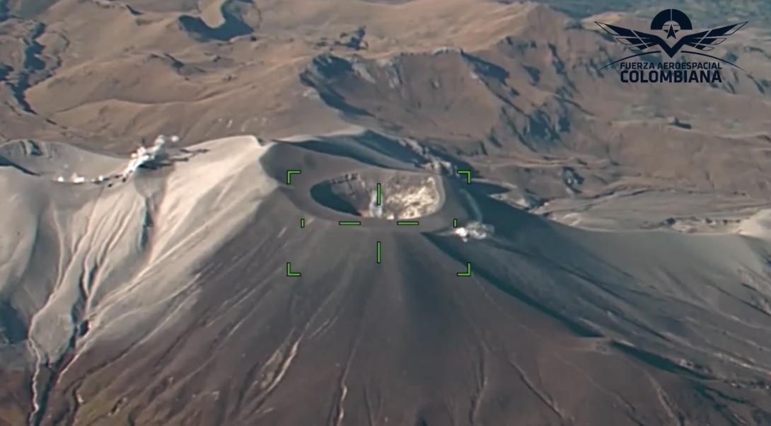
In order to alert the corresponding institutions in a timely manner and act effectively in the face of the volcanic activity in the crater of the Curiquinga and Puracé Volcanoes on January 20, the Colombian Aerospace Force in a coordinated work with the Ministry of Mines and Energy, the Colombian Geological Service and the UNGRD through the National Personnel Recovery Center- CENRP and the military operations resources of the Military Transport Air Command- CATAM, carried out a surveillance and reconnaissance overflight on the area of the Los Coconucos volcanic chain, in the department of Cauca.


A King-350 aircraft flew from Bogotá to conduct reconnaissance through electro-optical sensors, to take data of the surface of the mouth of the mentioned volcanoes and the current state of the area.


The information collected was later georeferenced and distributed to the Colombian Geological Service and the National Unit for Disaster Risk Management- UNGRD, through the CENRP, leading constant monitoring of volcanoes, evidence of gas and ash emission, thus facilitating decision-making for emergency care.


In this way, the Colombian Aerospace Force, as a member of the National System for Disaster Risk Management, puts at the service of Colombians all its air and technological resources to mitigate any type of threat in order to protect the good physical condition and life of the inhabitants.


Source: Public Communication Office CENRP

Blog tags
Colombian Aerospace Force
overflight
Los Coconucos volcanic chain - Cauca
Facebook
FB
X
X
Youtube
YT
Instagram
IG
Spotify
SF
21 January, 2025

Comando General Fuerzas Militares de Colombia 

Sede Principal 

Carrera 54 N°26-25 Barrio Esmeralda Bogotá D.C., Colombia

Código postal: 111071

Oficina de Atención al Ciudadano:

Carrera 59a N° 44B-29 Barrio Esmeralda Bogotá D.C., Colombia


Horario de Atención:

Lunes a Viernes de 8:00 a.m. a 4:00 p.m.


Línea de Atención: 

Gratuita Nivel Nacional +57 018000 952930 +57 (601)5804826 +57 3175765798 

Whatsapp:  + 57 3175765798

EJC 152 | ARC +57 3166192914 | FAC +57 3057341858

Línea anticorrupción 157


Correo Institucional: atencionalciudadano@cgfm.mil.co 

QUEJAS Y/O DENUNCIAS DISCIPLINARIAS 

NOTIFICACIONES JUDICIALES

notificacionjudicial@cgfm.mil.co


  • Facebook
  • X
  • Instagram
  • Youtube
  • TikTok
  • Linkedin
  • Threads
  • @COMANDANTE_FFMM

  • Políticas
  • Mapa del sitio
  • Términos y condiciones 
Procolombia
Gov.co
Reducir letra Reducir letra Aumentar letra Aumentar letra
Contraste Contraste
Centro de relevo Centro relevo